A Natural and Cultural History Guide to the Blue House
By Angela Burlile, graduate student in the Institute’s 16th cohort.
During our Place-Based Learning in the North Cascades course this past summer, I discovered the power of place and the role that place has on our sense of self and the development of our ecological identity. A sense of place can be developed when one purposefully considers their relationship to the landscape and builds meaningful and personal connections.
Throughout much of the summer, we examined a pedagogy of place, reinforced through experiential practice and supportive reading material. In David Gruenewald’s, “Foundations of Place: A Multidisciplinary Framework for Place-Conscious Education”, he states:
“A multidisciplinary analysis of place reveals the many ways that places are profoundly pedagogical. That is, as centers of experience, places teach us about how the world works and how our lives fit into the spaces we occupy. Further, places make us: as occupants of particular places with particular attributes, our identity and our possibilities are shaped.”
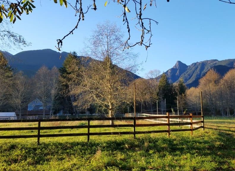
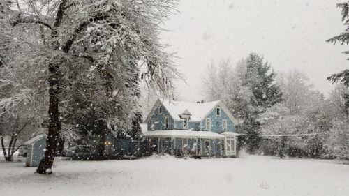
I carried Gruenewald’s words and the idea of purposeful examination and connection to land with me as I moved into my new graduate residence at the Blue House in August 2016. Purchased in 2015 by the North Cascades Institute, the Blue House provides residential housing space for graduate students and staff. It was built in 1912 and currently sits on 7.7 acres of land, along the confluence of Diobsud Creek and the Skagit River.
The Blue House property in Marblemount. Photo by Angela Burlile
Inspired by this examination of place, I chose to look at the Blue House property for my natural history project, researching this specific place through the lens of geology, climate, watershed, natural disturbances and cultural history. The following are brief overviews of some of the sections found within the guide. It is my hope that this information will help those who reside at or visit the Blue House, engage in the practice of natural history and put historical context to the property and the surrounding local area.
The Skagit River Watershed
The southeast border of the Blue House property extends down to the banks of the Skagit River. The Skagit watershed drains over 3,000 square miles – 2,730 square miles in Washington and 400 square miles in British Columbia. In Washington state, the Skagit Basin encompasses most of Skagit County and the northeastern parts of Snohomish and Whatcom counties. The headwaters of the Skagit begin in the mountains of Manning Provincial Park in British Columbia, flowing southeast for 32 miles to the U.S. border; it then flows south for 20 miles in Washington, turning west through the crest of the North Cascades and into Puget Sound.
Over 3,000 tributaries drain into the river, including the Sauk-Suiattle, Baker and Cascade rivers. More than 300 glaciers in the Cascade Range supply the Skagit River with cold water throughout the year and keep the flow of the river high throughout the summer. Ten billion gallons of water flow into Puget Sound each day from the Skagit River, equating to roughly twenty percent of all freshwater entering the Sound.
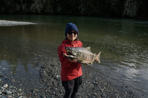
Diobsud Creek and the Skagit River are spawning habitat for all five native Pacific salmon species. Photo by Angela Burlile
The Skagit River serves as a major ecological and economic asset in Western Washington. The river supplies energy to Skagit county cities, Bellingham and Seattle through hydroelectric projects operated by Seattle City Light. The Skagit river also provides drinking water and irrigation for the agriculture sector, which drives much of the economy in Whatcom and Skagit county. The river is the only system in Washington that contains all five native Pacific salmon species, providing spawning habitat for chinook, coho, chum, pink and sockeye. Glacial water keeps the river at low enough temperatures that are optimal for salmon to survive.The largest population of bull trout also resides in the Skagit, as well as steelhead and cutthroat trout. The Skagit River hosts one of the largest concentrations of bald eagles in the lower 48 states, though the population fluctuates seasonally. In winter, bald eagles migrate from as far away as Alaska to eat the carcasses of spawning salmon. Flowing into Puget Sound, the Skagit delta provides winter habitat for 80 percent of western Washington’s waterfowl, and forging and staging areas for 70 percent of Puget Sound’s shorebird population .
Geology: Straight Creek Fault
The Blue House lies just east of the Straight Creek Fault. A fault is a break in the rocks that make up the Earth’s crust, along which rocks on either side have moved past each other. The Straight Creek Fault runs north-south and is considered a strike-slip fault. Strike-slip faults are vertical or near vertical fractures where the blocks have mostly moved horizontally.
Roughly 40-50 million years ago, the block on the west side of the fault shifted north at least 100 miles, possibly as far as 200 miles, relative to the east side. The rocks to the east of the Straight Creek fault are gneisses and granites whereas the rocks on to the west are completely different, comprised of recrystallized mudstones and sandstones. As you drive over the Straight Creek Fault, east of the Blue House, you notice that the valley narrows considerably. This is because the metamorphic rocks to the east are more resistant to erosion compared to the sedimentary rock to the west.
Climate
According to U.S. Climate Data, Marblemount receives roughly 76 inches of rain per year and averages a temperature of roughly 50 degrees Fahrenheit, with most of the accumulation occurring through the winter months. Two of the biggest elements that drive the wet and mild climate of this region are the Pacific Ocean and the Cascade mountains.
The Pacific Ocean moderates the air temperature as a result of the eastward moving jet stream. As the air moves across the Pacific Ocean, it takes on the temperature of the underlying ocean surface. During the winter months, the surface temperature of the mid-latitude northern Pacific Ocean (where much of the Pacific Northwest is situated) ranges between 45 to 50 degrees Fahrenheit. This mild and moist air reaches the Pacific Northwest, keeping our wintertime temperatures in the mid 40s.
In winter, low-pressure weather systems that produce rain and windy weather conditions follow the jet stream. During the rainiest months of winter, winds from the southwest bring moisture that first condenses over the Olympics and then pick up additional moisture as they cross Puget Sound. This moisture creates rain in the lower elevations of the Skagit Valley and snow in the higher elevations of the Cascades.
During the spring and summer, the jet stream and associated storms weaken and retreat northward while high pressure builds over the eastern Pacific. As this high pressure builds up offshore, cool air from the ocean blows over the Pacific Northwest, keeping summertime temperatures west of the Cascades relatively moderate, rarely exceeding 90 degrees.
The geographic location of Marblemount and its placement near the Straight Creek Fault also impacts the towns weather patterns. As mentioned earlier, the terrain of the valley becomes significantly narrow as you head east, due to a changing in rock composition and erosion from the last glaciation period. This geography causes an uplift in weather systems, influencing pressure and subsequently, precipitation levels.
Riparian Area
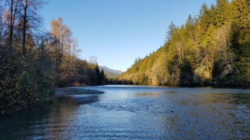
Looking east at the confluence of Diobsud Creek and the Skagit River behind the Blue House. Photo by Angela Burlile
Almost half of the Blue House property borders are comprised of a riparian area along Diobsud Creek and the Skagit River. A riparian area describes land that is adjacent to streams where vegetation, such as native grasses, flowers, shrubs, and trees, are strongly influenced by the presence of water. These areas or zones are important in maintaining good water quality, preventing sediment and pollutants from reaching a stream. The roots of riparian trees and shrubs help keep the streambanks in place, preventing erosion. They also provide valuable habitat for wildlife, providing food, nesting, and hiding places for many species.