Elk Xing
If you drive on State Route 20 between Sedro-Woolley and Concrete, you can participate in citizen science without even leaving your car.
Researchers at Western Washington University are studying elk crossings along this stretch of two-lane road, and they need your help. Their interest was prompted by the high incidence of collisions between vehicles and the 1,000-pound ungulates. Over 50 elk were reported killed by traffic in this zone in 2012, though it’s only a 20-mile stretch of highway. There were likely more fatalities that went undocumented. A year later, in 2013, reported elk roadkills fell to the low 30s. Since this was only the second year of concerted data collection for scientific study, it is impossible for researchers to discern any pattern.
Yet. Now scientists want to know: Exactly where and when are elk crossing the highway, and where and when are they killed? That’s where commuters, visitors and day-trippers come in. The observations of motorists and residents are an important component of their data gathering, so much so that the Washington Department of Fish and Wildlife has developed an “App” that makes it easy for people using the Internet or mobile devices to upload their observations. For those of us who hear “app” and get excited about pre-dinner small plates, here’s the simple breakdown: Step one: Download the App. Step 2: Choose your device to open the map. Step 3: Mark your elk sighting on the map, adding to the database and furthering the scientific understanding of elk behavior.
There is also a hotline and email address to report observations. Researchers remind drivers to be safe and not try to use the App while driving – photos and information can be uploaded later upon arriving at one’s destination.
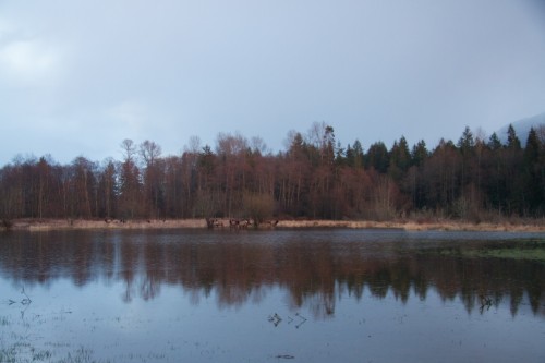 Can you see the elk? The typical habitat of the lower Skagit Valley, east of Interstate 5, where the North Cascades elk herd tends to hang out, to the chagrin of some and the joy of others. Photo by Jessica Haag.

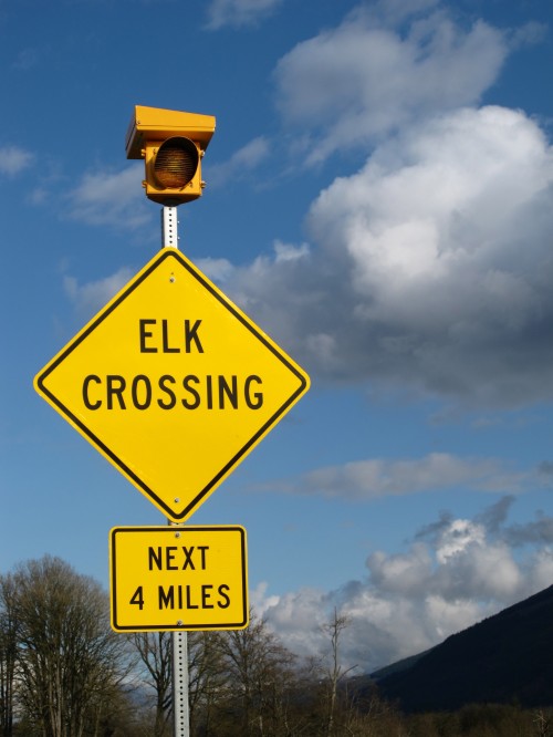
Other methods being used to track elk movements include using GPS collars and monitoring specific elk trails where they cross the asphalt. The Washington Department of Transportation is installing new elk crossing signs and additional mile markers to make it easier for motorists to identify and report exactly where they see elk cross the highway.
According to the Washington Department of Fish and Wildlife (WDFW), the North Cascade elk herd is the smallest of ten herds currently residing throughout the state. The herd was reintroduced in 1946 and 1948 from eastern and western Washington populations. Their numbers reached a peak of around 1,700 animals in 1984, took a nose dive in the late 1990s with only about 300 individuals, then ramped back up to a herd of 1,200 to 1,400 that we see today throughout Skagit and Whatcom counties. This population roller coaster can be attributed to changes in local timber harvest and rates of both legal and illegal elk hunting.
Habitat changes caused by increased timber harvest should have been favorable for elk population growth because young stands of saplings that replace the larger trees and thicker forest provide the open spaces and new growth that elk prefer for forage. Yet increased human access and visibility may have resulted in the mortality in the late 1990s of this elk population. Christopher Danilson, a WDFW biologist for Whatcom and Skagit counties who has been working with the Skagit elk population for over a decade, wrote in an email to Chattermarks that another issue at that time was that the elk were causing significant agricultural damage and WDFW was permitting high levels of elk harvest in these areas. Danilson attributed the population rebound over the past several years to restricted elk hunting, forest road closures and the augmentation of elk from Mount St. Helens in 2003, 2004 and 2005.
But not everyone thinks this robust population is a good thing. In fact, the North Cascades elk herd is rather controversial, so much so that WDFW hired a “wildlife conflict specialist” to mediate between different stakeholders. There are the hunters, the farmers, the conservationists, the tribal subsistence hunters, the motorists and the transportation officials, all with various perspectives, concerns and generally competing interests. This controversy is not new news. In 2002 WDFW released a management plan with ten objectives for managing the herd and solving conflicts, which included goals that some might consider mutually exclusive, such as “minimize elk damage to private property” and “preserve and enhance critical elk use areas”.
Over a decade later, the elk issue remains a tricky one to negotiate, and still unresolved. In June 2013, WDFW moderated a meeting in Sedro-Woolley to gather community input to inform their revision of the elk management plan and discuss the formation of a North Cascades Elk Management Group. Last October, Senator Kirk Pearson (R), Natural Resources and Parks Committee chairman, led a meeting in Mount Vernon attended by 120 people. Thirty-four testimonies were given. This was in the wake of gunners contracted from USDA’s Animal and Plant Health Inspection Service who attempted to cull an elk herd near Sedro-Woolley that had been damaging fences and trampling hay and corn, according to an online article from Northwest Sportsman.
Danilson wrote that these meetings serve to inform what WDFW will outline for the next steps and the longer-term vision for the local elk herd: “We are in the process of updating that herd plan which WDFW hopes to adopt by the end of this year. This process has involved considerable public input through a forum referred to as the North Cascades Elk Management Work Group, which has met regularly since last August.”
Given the diversity of concerned parties, a collaborative effort is challenging but vital. Public safety is a huge part of this complex puzzle, and that’s where the work of the researchers at Western becomes so relevant to this ongoing issue. Nathan Rice, an Environmental Studies graduate student spearheading the project, started monitoring elk crossings last summer. His research is funded by the Stillaguamish and Tulalip tribes. A number of other tribes and agencies are also involved, including the Upper Skagit tribe, the WDFW, the Washington Department of Transportation, Washington State Patrol and the Skagit County Sheriff. Additionally, Rice stressed the importance of motorist and resident participation. “This local knowledge is a great resource,” he said.
To download the App so that you can participate in this study, go to here.
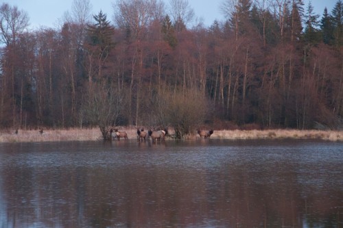 An elk watering hole near Sedro-Woolley. Photo by Jessica Haag.
Leading photo: Several elk crossing signs, many equipped with flashing amber-colored lights, are common along the stretch of Highway 20 between Sedro-Woolley and Concrete. Photo by author.

Katherine Renz is a graduate student in North Cascades Institute and Western Washington University’s M.Ed. program. Writing this post couldn’t help but prompt the question, “Why did the elk cross the road?”. Talk amongst yourselves.
Mismanagement by the WDFW, Rocky MT Elk foundation and the tribes. Shame on them.