Trail Guide to Ptarmigan Ridge
The North Cascades are a hiker’s paradise. The trail system that we enjoy in these northern mountains provides access to spectacular places and ranks among the world’s supreme networks of footpaths. The Ptarmigan Ridge Trail is one of the finest routes in the Mt. Baker area, a dream-walk along a sinuous high-country ridge that meanders across a landscape of unforgettable grandeur, delivering unparalleled “bang for the buck”.
Day Hike or Backpack Difficulty: 2.0 (to Coleman Pinnacle)
Wow Factor: 5 Distance: 13 kilometers/8 miles RT (to Coleman Pinnacle) Elevation Gain: 425 meters/1400 feet RT (to Coleman Pinnacle)
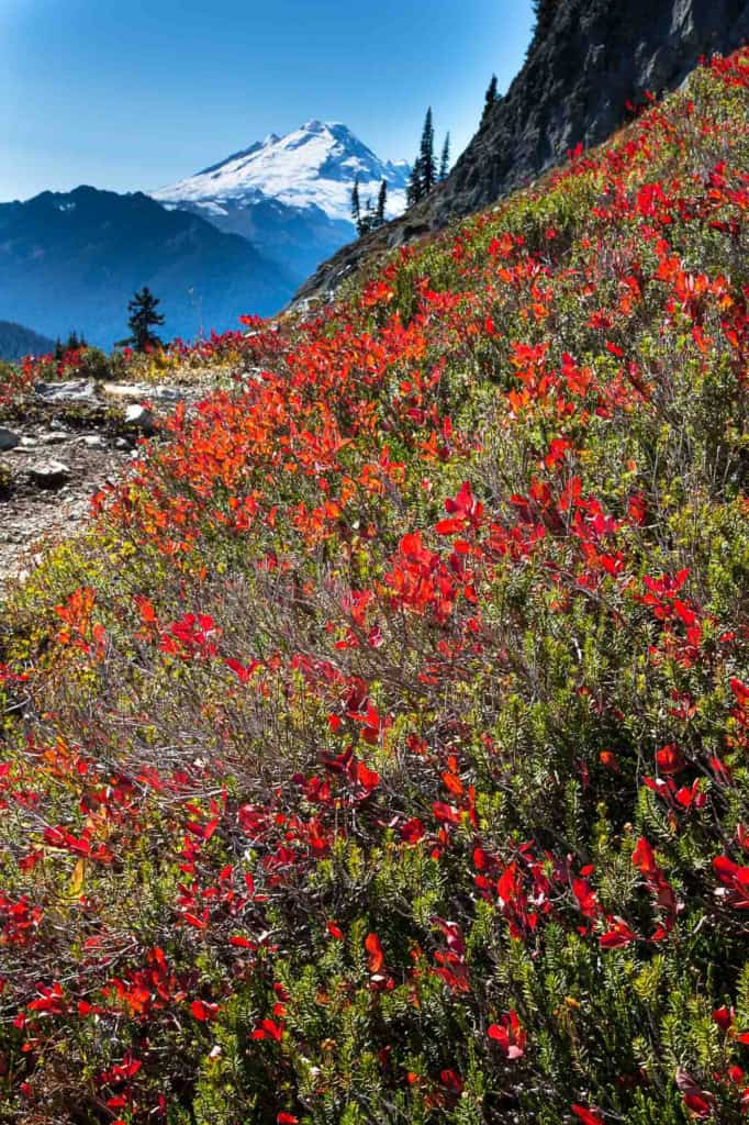
Pros: One of the best effort-to-reward ratios of any hike around Mt. Baker with close-up views of Mt. Baker and its glaciers, Mt. Shuksan and surrounding peaks, an alpine lake, alpine meadows, flowers, rock & snow. Mountain goats. Great Fall colors.
Cons: Crowded
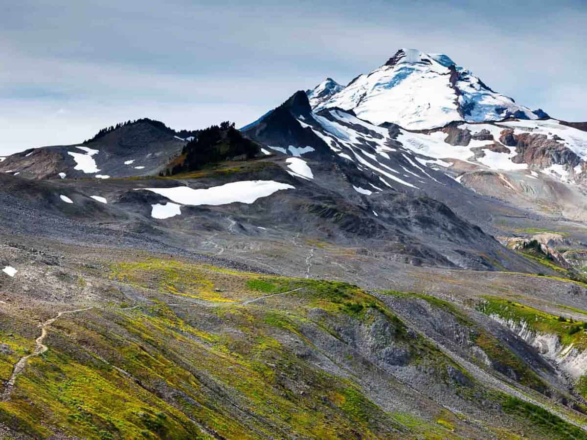
The hike makes for a perfect introduction to the glories of the Mt. Baker area: non-stop superlatives with almost zero huffing and grunting. In addition to the continuous panoramic views, the trail has something for everybody. Along the way, you’ll meander through gentle alpine meadows, cross beneath dramatic rocky cliffs, hop across sparkling brooks and enjoy sweetly-scented flower gardens. Farther along the ridge the landscape becomes more desolate and barren, offering an opportunity to observe titanic forces up close, the tumultuous topography exposed without a covering of vegetation.
It’s also one of the easiest hikes around Mt. Baker. Maybe. This route holds snow longer than most of the trails mentioned in this book and is frequently inaccessible until late summer or autumn. When snow-covered, it can be dangerous without an ice axe and the facility to use it. Under these conditions, casual hikers should turn back and visit the nearby Chain Lakes instead. But when the snow is (mostly) gone you can do this as a rapturous and straightforward day hike or memorable backpack.
Unusual in these mountains, the show starts immediately, with no preamble. From the first step, the views are extraordinary. Even the trailhead parking lot at Artist Point offers scenic splendor—and in recent years it’s become a very popular one indeed. Late-lingering drifts piled in huge banks beside the parking lot offer the novelty of easily-accessed summer snow, a delight for lowland visitors, who bring kids, saucers, and gleeful laughter. On sunny weekends, it’s packed. If you’re short on time or ambition, by all means, venture out at least to the junction where the Chain Lakes and Ptarmigan Ridge Trails split. No matter how far you go, you’ll be enraptured. It is rare to achieve such access to above-the-tree-line splendor with so little effort.
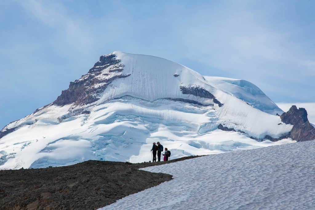
And in the distance, the beguiling black fang of the Coleman Pinnacle is irresistible, rising above the serpentine ridgeline. Knowing that soon you’ll be beside it, out there in that wild country quickens the blood and energizes the spirit.
A few cautionary notes: Under any conditions, trekking poles will be a godsend on this hike, helpful when crossing the snow patches that are almost always present out on the ridge. The ridge is exposed to the capricious elements and the weather can change in the blink of an eye so bring some extra clothes in your pack. Ptarmigan Ridge is famous for opaque white-outs that can make navigation challenging, so don’t wander away from the trail, lest you never return. It has happened.
From the northwest corner of the parking lot, the Chain Lakes Trail dips briefly and then traverses a broad open slope beneath the chiseled cliffs of Table Mountain. Immediately a chorus line of peaks is revealed to the east including glacier-swaddled Mt. Challenger.
Tiny rivulets tumble over polished stones, vast bowls of green meadow alternate with boulder fields, and the awe-inspiring summit of Mt. Baker, known to the original inhabitants of the area as Koma Kulshan, grows ever-larger as you get closer to its glacier-covered east face. Far below, Baker Lake can be seen to the south, a vivid blue-green among dark forests. Mountain goats can sometimes be spotted in the basin below the trail. Whistling marmots harmonize with squeaking pikas. As you might expect, ptarmigan are often seen rummaging in the greenery.
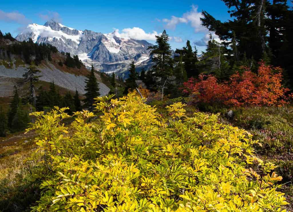
The grade is gentle and easy. And inspiring. In autumn, a profusion of blueberries might slow your progress.
In 1.9 kilometers (1.2 miles) reach the saddle between Table Mountain and Ptarmigan Ridge and a junction. Bear left, leaving the more popular Chain Lakes trail which turns right, and descend into a vast bowl. In mid-summer, monkey flowers bloom in profusion beside tumbling snow-melt creeks beneath somber columns of andesite formations. In autumn, the sweeping meadows are painted magenta and gold. The contrast between the dark cliffs, spare vegetation of the higher slopes, and the lush meadows far below is stunning. Camping is not allowed within one mile of the Chain Lakes junction.
From the rocky basin, the trail turns left and climbs along the ridgeline, sometimes becoming indistinct in the rocks and remnants of last winter’s snow. At the crest, turn right to follow the trail upward atop the ridge to a rocky outcropping just to the right of the trail, a fine spot to take a break, have a snack, and savor the awesome beauty.
When ready, press on. It gets better.
Heading southeast now, the trail traverses the steep ridge. Berries and clumps of krummholz give way to jumbled rock but the trail is artfully constructed and passage is easy to the next shoulder of the ridge, unless snow is present, in which case an ice axe would be de rigueur. A sharp turn to the west introduces another splendid traverse. It’s uphill, but the grade is forgiving and the ever-widening views will stimulate your adrenal glands. Expect to cross snow patches.
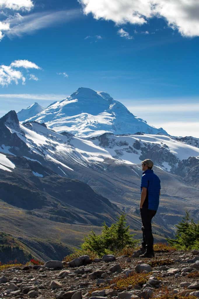
After 6.1 kilometers (3.8 miles) you’ll see a heartbreakingly beautiful little tarn below the trail to the south, known as either Goat, Mystic, or Glacier Lake, depending on who you ask. It’s relatively new on the scene, born in the last few decades as the glaciers have receded. Beyond the lake, the trail continues below the looming tower of Coleman Pinnacle, drawing hikers toward the now-nearby glaciers. The pinnacle is named for Edmund Coleman, the artistic soul who made the first ascent of Mt. Baker in 1868.
If so inclined, a challenging side trail offers an alternative—if somewhat sketchy—route, ascending talus slopes north toward the Pinnacle and west along the ridge’s knife-edge crest, affording stunning views along the way. The crest is surprisingly green and lush with small luxurious pocket meadows and scattered stands of gnarled krummholz trees. This route, more popular with goats than Homo Sapiens, rejoins the main route at a rocky plateau at the end of the official trail.
On the main trail, the surroundings become more austere and desolate, and the route climbs more aggressively to another shoulder of the ridge at 1737 meters (5700 feet), camping spots, and the end of the trail. The surrounding glaciers are truly impressive from here as you are looking down on them. The great stone gates known as The Portals are on full display, lending a “Hall of the Mountain King” look to the scene.
To the north, the Border Peaks nearly steal the show, rising like dark towers along the Canadian border. But there, front and center, is Koma Kulshan. The height of Mt. Baker is readily discernible for a hundred miles, but the sheer gargantuan mass of the volcano really hits home from this vantage point.
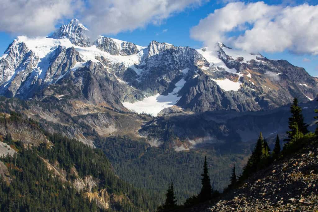
The hike back to Artist Point is magnificent—and quite different than the hike in. On the way in, Mt. Baker was the star of the show. On the way back, Mt. Shuksan dominates the scene. At the end of the day, if you are lucky, alpenglow will turn its high ridges pink and purple, a fitting coda to the day’s enchantment.
ACCESS: Drive Highway 542 (the Mount Baker Highway) 93 kilometers (58 miles) east of I-5 in Bellingham to its end above the upper Mt. Baker Ski area, bearing right near the upper lodge for the last 4.2 kilometers (2.6 miles) to Artist Point. Locate the Chain Lakes trailhead at the northwest end of the parking lot.
PERMITS: A Federal Recreation Pass is required.
STEWARDSHIP TIP: Ptarmigan Ridge is a very fragile place and demands extra vigilance on the part of visitors. The practice of ‘Leave No Trace’ ethics is essential, whether camping or day-hiking. If you leave the trail, walk on rocks or snow and avoid stepping on the vegetation. As mentioned, if backpacking use bear canisters to store your food and blue bags to remove human (and pet) waste. Speaking of which: please, please keep your dog on a leash. The marmots will thank you.
ADMINISTRATION: Mt. Baker-Snoqualmie National Forest, Mount Baker Ranger District