You Are Here : A Weekend of Maps at the North Cascades Institute
I sense that humans have an urge to map–and that this mapping instinct, like our opposable thumbs, is part of what makes us human.”
I was driving East on the North Cascades Highway Friday morning through the snow, when I suddenly realized I was further up the road than I had ever been. A sense of excitement came over me. I was exploring, I was on new terrain, seeing things I had only ever seen on maps with my very own eyes. Winding up the road past the rushing Skagit River I finally came to the turnoff for the North Cascades Environmental Learning Center a few miles from the end of the road, and made my way slowly across the Diablo Dam.

Several months before, I had seen a postcard in the Skagit Land Trust office from the North Cascades Institute with a list of the classes and workshops they were offering in the upcoming year. A friend leaned over my shoulder and said, “Look! A map class! You have to take it.” And so I signed up.
The Art of Drawing Maps was a chance for me to spend a weekend in the mountains, focus on creative work, and crank out some maps I had been thinking about making. It turned out to be so much more than I was expecting. Not only did I have the chance to work in a studio with a dozen other incredibly inspiring people, I also had the chance to meet several staff, enthusiastic Base Camp program participants, and resident graduate students on campus. I was happily surprised at the dining hall and the incredible food prepared by the amazing kitchen staff. And I briefly met Elvis, the residential Raven, who laughed at us once we became stranded at the Institute due to an avalanche four miles down the road. I think some of us were a little too adamant about tempting the avalanche as the snow piled up and the avalanche became a real possibility…did we forget to knock on wood?

Our instructor, professional illustrator and calligrapher Jocelyn Curry, gave demonstrations and tutorials on several aspects of design, including using a mapping ink nib with India ink, making thumbnail sketches, letterforms for titling and labeling, and how to add color and texture to our maps. She provided materials and a small stitched booklet of instruction, then set us free to create maps of our own. Some of my favorite ideas from the preliminary brainstorming period include “a map to my happy place,” a jack-o-lantern map, local star maps, and a secret squirrel cache map on the inside of a strand of birch bark.
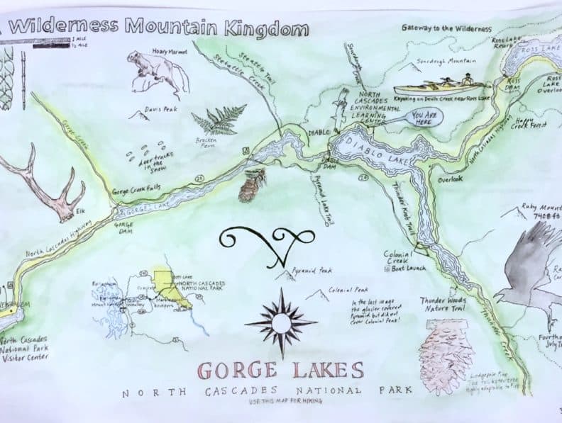
Inspired by the natural surroundings and the location of the North Cascades Institute, I began creating a map of the Gorge Lakes area starting with a simple water outline on Clearprint included in our supply folders. I really enjoyed the process of adding cartographic elements to the see-through paper by using other maps, guidebooks, and pamphlets to add trails, animals, plants, and sites of interest. It was fun, and we were encouraged to let go of perfectionism and let our imagination go wild.

On Friday afternoon, we hiked through the snow on the Peninsula trail along Lake Diablo. Inspired by that adventure, I added elements onto my map from my field notes. We saw several Lodgepole pines, a young Western hemlock with its “drooping leader,” deer tracks in the snow, and learned about the geology of the surrounding mountain peaks. Putting it all together on my map, adding watercolor, and finishing all the labels and drawings, I finally folded my map and created a Vade Mecum (the phrase means “go with me” in Latin), a portable booklet made from handmade paper and simple folding design Jocelyn had created for us to use.

I put some finishing touches of flamboyant sixteenth century map lettering on the cover, glued a blue jay feather to the inside and sealed it shut with wrapping string and stamped paper buttons. It will always be a special reminder of this time I spent in this wild mountain kingdom.

At the end of our extended stay at the NCI, there were several professional and beautiful maps of varying scales and locations. We travelled around the globe exploring each other’s maps, from Capitol Hill to Whidbey Island, visiting Joplin’s Nature Sanctuary and a few of our friends’ secluded natural properties, zooming out to honor the Puget Sound and the incredible diversity of wild foods and places we call home, flying over the North Cascades National Park, and making our way across continents and oceans stopping in Ireland, the Dominican Republic, and continuing on to “Terra Australis,” otherwise known as Antarctica.


It was an honor and a pleasure to work with this group of passionate, engaged artists from all different backgrounds.

The entire weekend was a testament to our ability as humans to create symbols, to formulate complex ideas, visualize and then execute our designs on paper. As geographer Stephen Hall writes, “we all travel with many maps, neatly folded and tucked away in the glove compartment of memory.” How wonderful it has been to see some of those maps make their way so elegantly onto paper. They will surely make impressions to all who get to see and share in their colors, lines, and stories. ∆ – Anders Rodin


Amazingily beautiful! What a gift to share this experience ! Thank you!