Mapping a Sense of Place
By Aly Gourd, graduate student in the Institute’s 15th cohort.
Imagine a world that makes sense. Mentally erase all of the tangled lines on the old, industrial-age maps — city, country, state, and provincial boundaries, highways and railroads, the international borders. Let the original face of the place shine through: rivers, mountains and valleys, coastlines and plateaus, sea and sky. −David Aberley
Maps are visual stories of place. They are rooted in observation and drawn by experience in landscape. Powers emanate from maps as they tell stories of direction, resources, and boundaries.
Consider the creators of maps. They are deciders of lines. Lines that often delineate who the land belongs to and who has the right to use what is there. Maps can splice, draw borders and represent the landscape in ways that can restore and destroy the environment.
Maps have the power to communicate and have served as a mechanism to support and discourage social and environmental justice.
As European settlers arrived in North America, explorers mapped the North American region as they learned of land and resources. Political borders were disputed and eventually drawn with little consideration for the topography and the responsibility to the region’s ecological systems. Many delineations of place drawn at this time continue to be represented on current maps.
hair-extensions-buy |
hair-extensions-buy |
hair-extensions-buy |
hair-extensions-cash |
light brown hair color
hair-extensions-hid |
red brown hair
extensions hair
hair-extensions-me |
hair-extensions-luxy |
hair extensions |
brown and blonde hair
hair extensions |
color hair
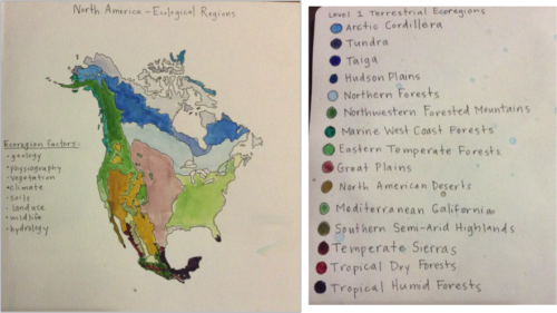
Mapping ecological factors to determine regions and the naturally drawn borders in landscape allows for full consideration of a place. Attention to ecological systems and the ways in which they function can sustainably guide responsible choices towards maintaining biodiversity present to each region.
Bioregions or ecological regions are areas of land defined by the ecosystem. Lines, borders, boundaries are drawn by the water, the mountains, the resources. Use of the resources depends not on claim by arbitrary boundaries, but on the knowledge and care of intricate ecosystems.
As David Aberley explains in the book “Boundaries of Home, “The promise is that these bioregions will be inhabited in a manner that respects ecological carrying capacity, engenders social justice, uses appropriate technology creatively, and allows for a rich interconnection between regionalized cultures.”
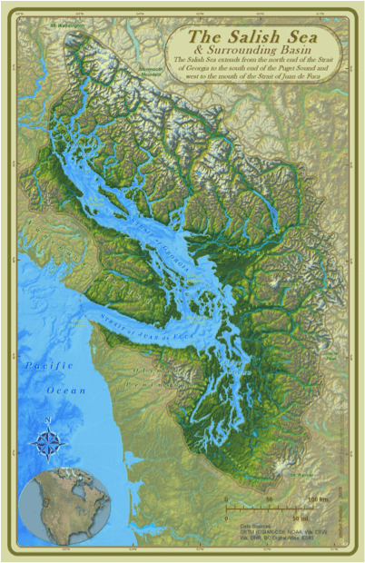
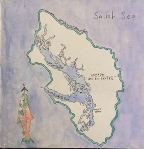
The Salish Sea
In 2008, the name Salish Sea was officially recognized by the Washington State Board on Geographic Names. The purpose of recognizing the area as such was to give a single name to the area that encompasses the Straight of Georgia, the Straight of Juan de Fuca, and the Puget Sound. Providing a name for the region encouraged ways of caring for a place that exists in shared political regions and insists a responsibility to understand the intricate systems of place. The official naming occurred in 2008, but original efforts to ensure acceptance of the name was not easy.
To eventuate common use of the name Salish Sea, a map of the Salish Sea was created (among other efforts). The Map of the Salish Sea & Surrounding Basin was made available to the public. Free distribution of the map allowed advocates for the area to visually demonstrate the area they were working to protect and speak to a place that exists within political borders of the United States and Canada.
The name Salish Sea intends to honor the original inhabitants of the area. “The Coast Salish have lived along the shores of the Salish Sea since the Pleistocene glaciers retreated north and the land and sea were emerging anew.” People arrived in the region as early as twelve thousand years ago and overtime discovered ways in which to sustainably survive in the area. The Coast Salish people have developed a strong relationship with the natural world and have lived as discoverers of place. Sustainable practices, although not originally known, were discovered with time in the area. The practice of honoring and paying close attention to the land revealed systems of sustainability.
Despite a rich cultural history, when European settlers arrived to the Pacific Coast, cultural traditions of the Coast Salish were devastated as control and power were exchanged between communities. European settler populations grew, as did the spread of disease and environmental degradation. In 1846, a border was drawn between the United States and Canada at the forty-ninth parallel. Later in 1872, a more refined border was drawn within the waters with no consideration of the connected ecological systems already in place.
The Coast Salish people survived in the Pacific Northwest due to knowledge and experience in place.
“Beyond static recreations of place, beyond the marking of a physical place, cognitive maps were at the very heart of aboriginal cultures. People who lived in place required a mental system that ordered information about an incredible amount of physical and ecological detail.”
Knowledge of the land was often in the minds of the people and therefore much of the knowledge was not documented on paper. Information was rarely written down because it needed to be known to survive. Oral histories were shared to communicate stories and information of place, passed through generations of people. As disease caused catastrophic grief within Native communities — histories were lost and communities were fractured. Opportunity to gain control of the land was seized and Native communities were uprooted from lands they had known for generations.
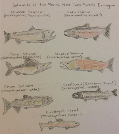
The Coast Salish cultural traditions reflect great attention to the natural world. The resources, once abundant in the region, “offered the stability to build a rich culture and life way that honored sustainability.” Communities typically situated themselves closest to areas abundant in resources and often organized nearest to the best fishing sites. Seven species of salmonids evolved in the waters of the Salish Sea that currently live in the Salish Sea waters. Although modern salmon emerged between one and two million years ago, it wasn’t until the environment stabilized around 5,000 years ago that humans began to depend on the Pacific salmon as a primary food source.
Fishing techniques developed to sustain the lives of the Coast Salish people. Intricate nets of cedar were used to fish from canoes and platforms, called reef nets. The reef net was created roughly one thousand years ago. Currently, reef net technology is used today for fishing and is viewed as a sustainable technique for catching salmon.
As Native populations decreased and borders were drawn, control of precious fishing land was lost to settlers, along with many of the sustainable practices that worked to ensure the return of the Pacific salmon. The relationship Native populations had to the Pacific salmon especially represent the original organization of indigenous communities and the dependence of a balanced ecosystem for human survival.
Currently, three species of salmon are in decline in the Salish Sea waters. Coho, Chinook, and Steelhead are declining specifically in the Salish Sea while they are remaining stable along the Washington Coast. Reasons for the decline of salmon can be attributed to loss of salmon habitat as well as industrial related pollution to the Salish Sea waters.
In the book The Bioregional Imagination: Literature, Ecology, and Place, Lawrence Buell is quoted in reference to explaining the environmental crisis:
“[The environmental crisis is a] ‘crisis of the imagination’ and that solving this crisis depends on finding ways to imagine nature and humanity’s relation to it.”
Healing the Salish Sea to reestablish once abundant salmon runs is not simply about regulating fishing rights. Instead, full attention to the interconnectedness of the land and the biodiversity that holds together the ecosystem of the Salish Sea will lead us to living and caring for a place simultaneously.
As David Aberley explains, “There is increasing thought about how mapping can relate to sustainability, preservation of biodiversity, and reclaiming of ‘the commons. Beyond the use of maps to solve rear-guard land use disputes, this is mapping as the center of a struggle to reclaim an interconnected web of wild ecosystems.”
The way that we choose to draw borders and lines on our maps has great power in how we impact the land. People have the power to advocate for wild places. Whether it is through mapping, literature, or speech, creatively approaching environmental concerns will bring strong voice to the places we are connected to and care about.