Fire and Ice: How Lava and Glaciers Formed Mount Baker
This Naturalist Note is written by graduate student Marissa Bluestein, as part of the Fall Natural History Project In North Cascades Institute’s M.Ed. Residency coursework. You can view other students’ work here.
It was a cool August day as our graduate cohort slowly meandered to an open space of grass at Rasar State Park. An enormous Douglas-fir towered over the walkway and five of my fellow cohort members were wrapped around its massive trunk with arms extended, as we awaited the arrival of North Cascades National Park geologist Jon Riedel. I had just become familiar with how to identify a Douglas-fir, and contemplating the geological formation of mountains as rugged and majestic as the North Cascades sounded like a tall order. As I sat on the grass soaking up the tiniest ray of sunshine protruding through the cloud cover, a National Park Service vehicle pulled into the parking lot. Carrying two large poster tubes, Jon Riedel made his way over to our group.
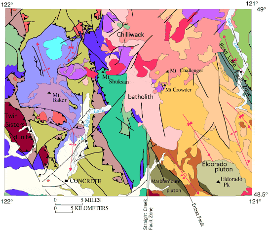
He grabbed one of the two poster tubes and pulled out a map of the North Cascades. Using this map as a tool he started to carefully explain the geologic development that took place 80-100 million years ago. Words like accretion, Eocene, cascade uplift and glaciation became more understandable as he pointed out how glaciers gain volume and how subduction and plate tectonics formed the Cascades.
Being from the glacier-free desert of New Mexico, I quickly became intrigued by Riedel’s description of glaciation and the significance of glaciers serving as a direct measure of climate change. His knowledge of how glaciers have helped form the present-day landscape and his passion for the preservation of the North Cascades glaciers inspired me to tackle a subject that for me, lies in uncharted territory.
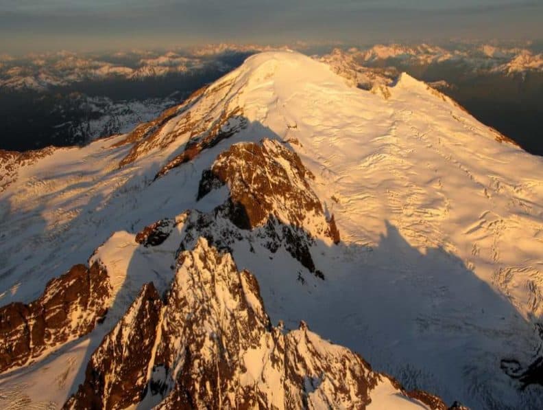
To the Nooksack people — the original inhabitants of northwestern Washington State — Mount Baker is known as Koma Kulshan, or “steep white mountain.” Sitting 15 miles south of the Canadian border and covered in white, jagged ridges, Mount Baker is the northernmost United States volcano in the Cascade Range. With 20 square miles of active glaciers, it is the most heavily glaciated peak after Mount Rainier in the range. Standing at 10,781 feet, Mount Baker receives world record-setting annual snowfall, and this heavyaccumulation help build glaciers.
Mount Baker is a young stratovolcano, characterized by its’ steep sides and many layers of volcanic rock and ash. Lava and glaciers share a dynamic relationship that has shaped Mount Baker’s landscape. We commonly think of lava flows as aggressive, relentless and unstoppable. However, glaciers can exert some control over the movement of lava flows, thus making them landscape architects. Glacial activity on high-altitude stratovolcanoes have illustrated the ability of ice to dam, deflect, and confine flowing lava. As lava flows are redirected by glaciers, they take the path of least resistance and flow into canyons and valleys where they cool and solidify. Over time, lava flows build on top of one another forming ridges in a pattern on the steep slopes of the volcano. As glaciers advance and retreat, the erosion of the landscape leaves the lava ridges exposed.
Glaciers are slow moving sheets of ice, which cause erosion by grinding on rocks. Glacial erosion of lava flows has produced an interesting landscape on Mount Baker, with ice-scoured individual lava flows creating a stair stepped like landscape. The Easton Glacier of Mount Baker demonstrates how lava and glaciers share a dynamic relationship in shaping the rugged volcanic landscape.
Lava flows, glaciers and ice erosion all play a part in creating the landscape Mount Baker currently occupies. These processes have taken hundreds of thousands of years to transform the landscape in to what we see today. Glaciers are melting faster than ever due to climate change and in order for Mount Baker’s landscape to keep from drastically changing, action must be taken. Glaciers provide drinking water, water for crops, ideal salmon spawning habitat and power our cities through hydroelectricity. Take glaciers out of the equation and life in the North Cascades region will change indefinitely. Hope is not lost and with action from our communities we can fight climate change and preserve this beautiful landscape.
For more information about Mount Baker’s history, formation, glaciers and climate change please check out these resources:
Skagit Climate Science Consortium
Mt. Baker Volcanic Research Center
~ Marissa Bluestein