"Too High and Too Steep": David Williams' new book on reshaping Seattle
Guest post by David B. Williams
Williams’ reads from his new book Too High and Too Steep: Reshaping Seattle’s Topography at Village Books in Bellingham on September 16 at 7 pm as part of our Nature of Writing Fall Speaker Series; free!
More so than most cities, Seattle has shaped itself to suit its needs. The citizens of Seattle have dug up, dug into, dumped upon, and carted away its original topography as few other cities have. They eliminated hills, cut canals, killed rivers, replumbed lakes, and built islands, in the process completely reshaping many parts of the landscape. And they did most of this within 75 years of the settlers’ landing. Too High and Too Steep: Reshaping Seattle’s Topography explores these unprecedented engineering projects by weaving together history, geology, and on the ground exploration.
As Michael Upchurch wrote in a Seattle Times review: “Williams does a marvelous job of evoking the cityscape that used to be. He clues us in to the spirit of civic ambition that drove Seattle’s geographical transformations. He methodically chronicles the stages by which its regrade, canal and landfill projects were accomplished. And he’s meticulous about placing his readers on present-day street corners where they can, with some sleight of mind, glimpse the hills, lake shores and tide flats that vanished. (Maps, illustrations and archival photographs help.)”
Building Seattle – A few tidbits on interest discussed in Too High and Too Steep.
- Filling in the tideflats of the Duwamish River created approximately 2,500 acres of new land.
- No dirt from Denny Hill went into making Harbor Island.
- The largest single hill regrading took place around Jackson Street when 56 blocks were regraded between 1907 and 1909.
- Nearby was the Dearborn Street regrade, which created the valley now spanned by the Jose Rizal Bridge on Twelfth Avenue.
- When Lake Washington was lowered by nine feet with the construction of the Lake Washington Ship Canal and Hiram M. Chittenden Locks, it led to the loss of 90 percent of the lake’s wetlands.
- Building the locks and canal resulted in the establishment of one of the final whaling fleets in the United States, which overwintered in Meydenbauer Bay.
- Total dirt moved during the city’s various engineering projects was at least 75 million cubic yards.
- The regrades were paid for by people who lived in the regrades, not by the city.
- One failed project called for a canal through Beacon Hill to connect Elliott Bay with Lake Washington.
- Seattle’s first big tunnel under the city, which runs for a mile, was cut by hand and completed on time.
- When the Alaskan Way Viaduct was completed, the Seattle P-I labeled it the “royal necklace across the bosom of the Queen City of the Pacific Northwest.”
From the Preface
When I was a child my father worked with Brewster Denny, great grandson of Seattle’s founding father, Arthur Denny. I thought this was pretty neat and remember interviewing him in third grade for an assignment I had on Seattle history. I don’t know if it was during this interview or later in life but at some point I learned that Brewster had known Arthur’s son, Rolland, who was six weeks old when the schooner Exact dropped off the twenty-two people considered to be Seattle’s founding families. I found it amazing that I knew someone who knew someone who had actually arrived on the boat that started the story of Seattle. It led to a life long enthusiasm for Seattle and its stories. That connection to the Denny family also cemented in my mind the idea that I live in a place with a relatively short history that is both accessible and tangible.
As I got older, I continued to be fascinated with Seattle’s past, and tried to weave that passion into a previous book, The Seattle Street-Smart Naturalist: Field Notes from the City. My goal was to explore the intersection between people and the natural world in what many call the least wild place on earth, the urban environment, while at the same time to consider the historical connections to this theme in Seattle. One of my favorite chapters was about the seven hills of Seattle, how they formed during the last ice age, and how they influenced our actions in the modern city.
Too High and Too Steep: Reshaping Seattle’s Topography is an outgrowth of my seven hills chapter in that I tell the story of Seattle through its topography. Those of us who grew up in Seattle with duck-and-cover earthquake drills and the eruption of Mount Saint Helens learned more viscerally than children in more stable locations that geologic forces played, and still play, a rather significant role in shaping the landscape. What we didn’t always learn is the extent to which humans were a critical force in altering the environment. From lopping off hills to covering over tideflats to reengineering lakes, Seattleites have created a surprisingly unnatural landscape that affected and still affects us everyday, often in ways we do not perceive. This is the subject of my book.
Despite all of the changes to the landscape, there is little obvious to the casual observer to show how we have reshaped the topography. With a little sleuthing though, stories can be unearthed that reveal the changes our predecessors made. The stories can be seen in parking lots, where cars sit catawampus to each other because the ground underneath is a former tidal swamp, and in train tracks that make a broad sweep instead of going straight because the tracks were laid before the lowering of Lake Washington. They can be found in bore hole cores filled with the detritus of bygone industries and in early newspaper accounts that describe the drama of a young town determined to be a big city.
The existence of these clues inspired me to write Too High and Too Steep. Throughout the book I will point them out, hoping to do so in a manner that encourages you to get outside and explore Seattle’s natural and unnatural landscape. Wherever possible I have tried to bring you with me by getting out on the ground, looking at the buildings, and probing the subsurface. When that hasn’t been possible I have turned to photographs and maps in order to put you on features that no longer exists or no longer look like they did before and during these projects. My hope is that you come away with a better understanding of not only how we have shaped the landscape but how the landscape has shaped Seattle and those who live here.
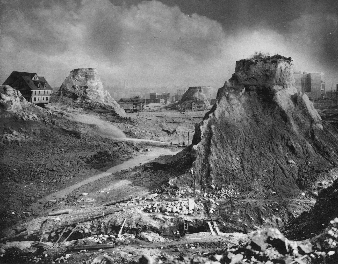
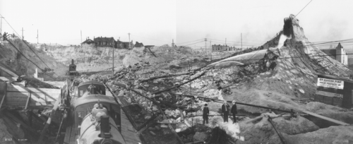
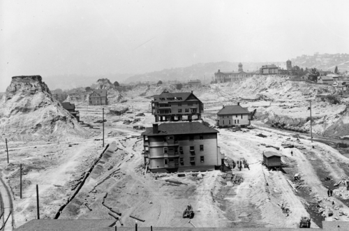
Photos, top to bottom: “Spite Mounds” – Asahel Curtis, 1910, Courtesy of University of Washington Special Collections; Asahel Curtis panorama of regrades. August 1907 Courtesy of University of Washington Special Collections; Houses in the Denny Regrade. June 1910. by James Lee, Courtesy of University of Washington Special Collections.