
“Smokestorm” over Cascadia
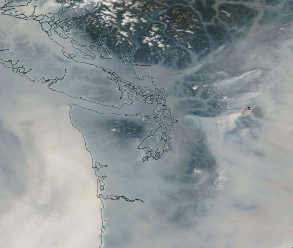
As anyone living in the Pacific Northwest knows intimately, the past two weeks have been incredibly hazy throughout our region as smoke from wildfires burning in British Columbia and the North Cascades has been pushed across our state, blurring our mountains, filling our valleys and choking out our cities. Just look at this view of the spreading smokestorm from space:
As reported in The Stranger, “Scientists widely cite climate change as the root cause of the wildfires smoking out the west. A warmer climate in Washington leads to drier soils, which increases the risk of wildfires. The Environmental Protection Agency predicts that “the climate is likely to more than double the area in the Northwest burned by forest fires during an average year by the end of the 21st century.” Fuel accumulation and sprawl increase the devastation of these fires.”
(Read an in-depth interview with Washington State’s Commissioner of Public Lands, Hilary Franz and find out “Are Smoky Summers the New Normal?” here.)
The air quality in Vancouver and Seattle this week has been worse than in Beijing, one of the world’s most notoriously polluted cities, with the Air Quality Index for Seattle reaching 190 on Wednesday — a rating classified as “unhealthy” — and other nearby cities like Port Angeles and Port Townsend hitting 205 — “very unhealthy.”
Here in the North Cascades, five lightning-ignited fires are burning or being monitored in North Cascades National Park Service Complex. Four fires are located in the North Unit of the Park Complex, and one in the Flat Creek drainage. A fire in British Columbia has closed vehicle access to Hozomeen as of Thursday, August 9, until further notice. Get the latest info on fires and park closures at www.nps.gov/noca.

There are several significant fires burning on the eastslope of the mountains including the Holman Fire in the Pasayten, which has closed the Pacific Crest Trail; the McCleod Fire near the Twisp River in the Okanogan National Forest; the Crescent Mountain Fire near the north end of Lake Chelan and the Cougar Creek Fire near Lake Wenatchee.
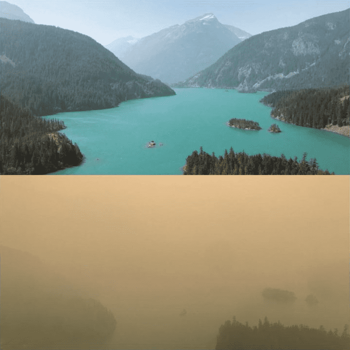
The North Cascades Environmental Learning Center and Diablo Lake neighborhood has been, like everywhere else, smokey, with conditions varying each day. Our scheduled programs have carried on, including Youth Leadership Adventures, Skagit Tours and a Sierra Club National Outing Retreat.

Later today, the winds are forecasted to shift and bring cooler, cleaner marine air inland, giving at least the west side of the Cascades some relief. There is even rain in the forecast, with showers coming as early as Friday and increasing through the weekend.
Water and a shift in wind is what the whole of the Pacific Northwest needs the most, so do your best rain dance!
What shall we do? Adopt policies that reduce carbon immediately (you can help by voting for Initiative 1631 this November!), do a lot more prescribed burning, restrict housing in forested areas, foster maintenance of defensible space around existing homes, and get used to smoke. I’m afraid this is likely how it’s going to be in late summer for the remainder of our lives.
— Mitch Friedman, Conservation Northwest
Useful links for getting more information about the smoke and weather:
UW Meterologist Cliff Mass’ weather blog